


Wheatley flooded 23 September 2024

Wheatley was flooded on 23 September 2024 as a result of more than 10cm of very heavy rain falling in just 12 hours, far more than the expected monthly average of 6cm).
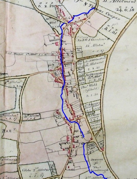
The first image shows the original line of the stream. It follows the line of the High Street until it turns west (left on the map) to avoid a small incline just before the parade of shops (now built on the blank site) and then running behind the houses before turning east (right on the map) at the bottom of the High Street.
Over 100 years ago, by the end of 1858, the stream had been culverted down the entire length of the High Street. See record 0920
Reportedly +10cm of rain (1 month's rainfall) fell overnight 22/23 September falling onto the much higher Shotover Plain way to the top of the map in the first image and continuing through much of the day. The ‘stream’ starts on this Plain.
The water cascaded from Shotover Plain arriving in the High Street at about 7.30, and became a ‘raging torrent’. Many houses and businesses at this western end and further down the High Street towards Bell Lane were flooded, with several properties in Bell Lane also flooded, with water surging up from any drains and invading from within the house or at its rear.. The water rose up the incline adjacent the parade of shops in the High Street up to the east end of Wheatley Estates, but none of these was flooded. Where the original stream turned south, before the parade of shops, the water (facing this incline) then follows the original line of the steam behind the parade and the High Street houses. At the back of the shops, the water level rose to about one metre, with the result that cars parked and many houses in Farm Close Road were also flooded. This was a much higher level than the flood of 2012, see record 2859.
The houses in the lower part of the High Street (where the stream used to run), suffered the most serious damage. The volume of water was so great that a huge lake must have formed behind these houses and then invaded the houses (many with basements or cellars) before flowing out into the High Street. Most, if not all of houses from No. 80 to the URC, appear to have been very badly affected with owners having to move out. In Crown Square, the flood broke through the tarmac after, presumably, entering the drainage system.
While the total number of houses affected is not known, it was probably some 50 in the main village with five houses in Kiln Lane flooded, numerous businesses and houses in High Street, 3-4 in Bell Lane, several in Farm Close Road, and one property (built at a lower level and adjacent the line of the old stream) in Farm Close Lane. Houses in the Keydale area and in Littleworth were also affected.
Residents, whose homes were not affected by the deluge, and the fire brigade performed magnificently helping the those whose homes were invaded with the water.
For historical records of dates that the culvert was created and other matters see record 2663.
More detail later.